How to buy the best handheld GPS
Hiking and camping or navigating the city, find the right device to show you the way.
Last updated: 23 Sep 2019
If your sense of direction is a bit out of whack and you need help navigating the bush, or even the city, a handheld GPS can serve as your own personal pocket tour guide. It can give your position if you’re lost, or record your every step so you can find your way back to where you came from. If you know the coordinates of a destination anywhere in the world, it will show you how to get there by foot. Now that’s pretty handy, right?
On this page:
How GPS works
GPS works by collecting information from a group of satellites that constantly orbit the earth. You only need a connection with three satellites to get a 2D position, with a fourth connection needed to calculate height.
Under a clear sky, you can expect a handheld GPS to take just a few seconds to calculate its position. However, if you’re in dense foliage it might take a bit longer. Once a location or route is established, the GPS will keep track of its position and speed to give you information on where you’ve been and where you’re headed.
Can’t I just use my smartphone instead of a handheld GPS?
Smartphones come with inbuilt GPS, but they need to be connected to a data network in order to load map information – which isn’t always realistic when you’re out bush. You can pre-load maps of where you’re going, but these can take up a lot of memory and they might not have all the topographic information you need. A handheld GPS lets you go further off the beaten track.
Points of interest
Saving points of interest (or waypoints) along your journey, like a river crossing, interesting rock formation or even a hard-to-find bookstore, is easily done by pressing a button or two and can be invaluable if you re-visit the area.
You can even record your entire journey – creating an evolving snail-trail as you move – which you can use again in the future or to track back to your original location.
If you’ve saved points of interest on your handheld GPS you can just enter these coordinates into Google Earth to show your lucky friends the places you’ve visited. No need to bore them with a slideshow!
How much should I pay for a handheld GPS?
Models range in price from $139 to $799.
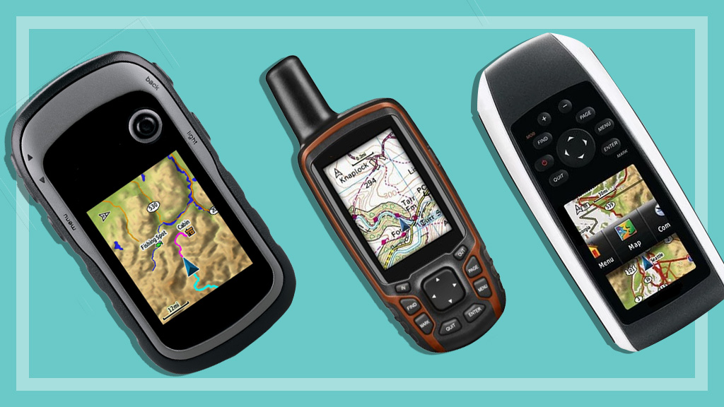
Features to look for in a handheld GPS
Screen
A high-resolution, and preferably colour, screen is necessary if you want to use detailed topographical maps.
Comfort
The unit needs to be comfortable in your hand, with well-spaced buttons that allow you to select functions easily.
Some models have small buttons and a joystick to control the various settings, while others are larger with a bigger screen and wider buttons. If you have large hands, or want to use the GPS with gloves on, a larger unit could be a good option for you.
Batteries
Most units can use both rechargeable batteries or normal alkaline batteries (AA or AAA). Others are powered by a rechargeable Li-ion battery, with AAA battery adapter as standard in the box.
Alarm
Most units have an alarm to let you know when you’ve arrived back at the starting point or if you’ve moved too far off the saved path.
Maps
Units usually come with a basic world map, but if you need a more detailed topographic map for extreme exploring you’ll need to fork out a bit more cash. Some units even support marine navigation maps – again, an additional expense.
PC mapping software
This allows you to select a point of interest or route, and download it to your GPS in advance. And if you want to show off what a hardy bushwalker you are, you can upload routes back to a map on your PC to show where you’ve been.
Connectivity cable
This allows your GPS to connect to a PC to download and upload information. But beware – these cables can be expensive if they use a proprietary connection.
Handheld GPS Jargon buster
GPS Global Positioning System.
Fix A successful connection with a group of orbiting satellites.
GLONASS Russian satellite system. Many of the latest models support both GPS and GLONASS for a faster positional fix.
Topographic map Shows elevation through the use of contour lines and altitude markings.
Waypoint or POI (point of interest) An exact coordinate marked to show a position.
Safety alert – Be prepared!
A handheld GPS will give you very accurate readings, but it’s still a good idea to learn how to get yourself around without it – just in case it dies on you in the middle of nowhere. Learning to use a compass and map for anything longer than a stroll in the park is a good skill to have as back-up.
Denis Gallagher is a Senior project officer for Digital home products and also works on test projects for the laundry and fridge labs. He produces tests for gadgets, phones, cameras and home entertainment gear as well as TVs, washing machines, dishwashers and fridges.
Previously at CHOICE, Denis worked as a Content producer for digital products. Prior to CHOICE, Denis worked as an Assistant editor on Golf Australia magazine and Editor for Multimedia and Videocamera magazine.
Denis has a Bachelor of Arts from the University of New South Wales and a Diploma of Journalism from Macleay College.